Time and Reality

The Measurement of Time

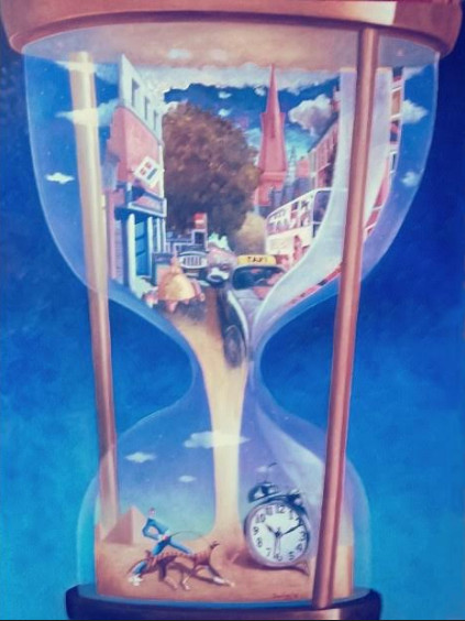
The Measurement of Time Oil on Canvas 48X36ins

Here are two new paintings concerned with the intangible nature of time and reality.  Time is a very slippery customer.  If you try to get your hands on time, it trickles through your fingers like sand running through an hourglass. Everyone is sure that time is there but they just can’t get hold of it.  Maybe they can’t get hold of it because it isn’t there at all.  But if it isn’t there at all, why does it play such a fundamental role in every moment of our existence?

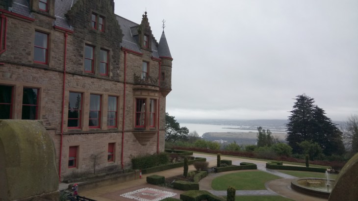
My first painting shows an hourglass, a traditional and ancient measure of time. The upper globe shows the busy Antrim Road, Belfast, at Atlantic Avenue.  It captures a moment in everyday life, a moment in time.  The sands of time drain into the lower globe but into a very different world. The timeless Great Pyramids of Giza and another traditional measure of time dominate the background while a man and a dog stroll past in the foreground.  This collection of disparate paraphernalia is simply food for thought. It is for the viewer to come to his or her own conclusion.

The Enigma of Reality

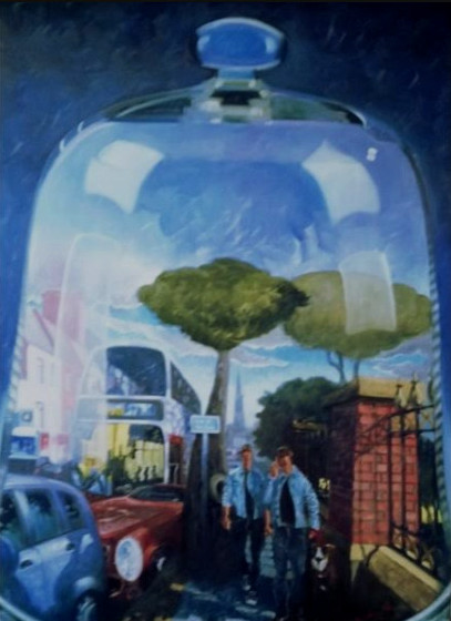
The Enigma of Reality Oil on Canvas 48X36ins

The second painting again draws its imagery from the Antrim Road, close to where I live and work.  It is concerned with the nature of reality.  Reality seems to be very fundamental and dependable.  Something, with whatever amount of poking and prodding, remains reassuringly solid.  However, think about our modern-day lust for simulated reality and our many journies in cyberspace.  Could we be a brain in a bell jar? Again food for thought.  Both paintings will be exhibited at the Royal Ulster Academy Exhibition at the Ulster Museum, Stranmillis, Belfast from 19th October 2018.


Slieve Commedagh and Donard from Newcastle

Commedagh1

This is a wonderful walk.  I would rate it as difficult as it includes two of the highest peaks in the Mournes.  However, the views of the Kingdom of Mourne make up for all that hard work.  For a map and statistics  go to www.wikiloc.com/running-trails/commedagh-donard-circuit-27975006

Start the walk in Donard car park on the southern side of Newcastle.  Leave the car park through the distinctive archway and turn left on to the Bryansford Road.  Follow the road to reach Tipperary Wood on the left at a road bridge over the Shimna River.  This is a lovely riverside walk which leads to Tipperary Lane, past Tipperary House and up to a narrow tarmac road.  Turn right on the tarmac road and then veer left on to an even narrower road which will take you steeply uphill. Go through a gate at the end of the road and cross a step stile beside another gate.  A forest track zigzags uphill and you turn sharp left at the first intersection and left again to reach the Drinns.

Donard2

At the Drinns you will see a small gate which will give you access to the rugged slopes.  There is a rough track from the gate but head roughly southwards towards a gap between a rounded hill close to the forest and the much larger Slievenabrock.  You will reach a ruined dry stone wall, step through a gap and start climbing steeply to reach the cairn on top of Shan Slieve.  Now follow a series of white posts to reach Slieve Commedagh at 767 metres.  Slieve Commedagh (from Irish Sliabh Coimhéideach, meaning the guarding, watching mountain) has a beautifully rounded summit with a prominent lookout tower dated 1913, built into the Mourne Wall.  From here there are wonderful views, in every direction, of the Kingdom of Mourne.

Donard1

Follow the Mourne Wall down a grassy slope to start the ascent of Slieve Donard, (from Irish: Sliabh Dónairt, meaning “Dónairt’s mountain”). The ascent is steep with some small well-embedded boulders in place.

Donard6

It is not possible to see the summit until you are almost there.  At the top, there is another tower dated 1910 and, of course, at 850 metres, wonderful views.

To return to Donard car park, retrace your steps back down Donard.  Then turn right at the bottom to reach a large cairn and then a rugged stone staircase to reach the Glen River.  Follow the river past the eighteenth-century ice house and eventually back to the car park.

Donard5


A week in London-Trinity Buoy Wharf


TBW3

The O2 Arena ( former Millennium Dome) from Trinity Buoy Wharf

My friend Gary and I recently spent a week in London.  We went in search of the lesser known sights of the capital, the interesting and the obscure, well away from the relentless tramp of the tourist. Trinity Buoy Wharf certainly fell into this category.

Trinity Buoy Wharf is the Thameside site where all the buoys and markers for the River Thames were once made and repaired. The site was rescued from dereliction and now its lighthouse (the only one in the capital) overlooks a growing creative community.

TBW6

The Lighthouse

Preserving the Grade II-listed warehouses, the developers have constructed artists’ studios, offices and a riverside café from recycled shipping containers and forged relationships with London’s art colleges, whose students are delighted to have access to the site’s large spaces for ambitious projects. ENO make all their props there, the Roal Drawing School have their Foundation Year Art School there and there are a host of other creative tenants. The fleet of Thames Clippers is based there – at one of London’s longest piers, which was built almost entirely from recycled materials.

Also located on the site are a nostalgic ’40s food joint, FatBoy’s Diner, and what may be London’s smallest museum, The Faraday Project. Housed in a tiny wooden hut, it’s devoted to the Victorian scientist Michael Faraday who conducted experiments into electric lighting in the lighthouse in 1863.

TBW1

Artist’s Studios and Offices

TBW4

The Faraday Project

Today the lighthouse is an unusual art venue (open to the public at weekends, 11am-5pm in summer, 11am-4pm in winter), hosting Jem Finer’s ‘Longplayer’, a digital musical composition, commisioned by Artangel and designed to play in real-time, without repetition, for a millennium.  An installation by Ingrid Hu of 234 singing bowls is part of a 667ft wide instrument used on occasion to perform a section of ‘Longplayer’ live.

The most exciting way to get to Trinity Buoy Wharf is by taking a short ferry trip across the Thames from the O2 QEII Pier (Mon-Fri 5am-7pm; £2 each way).   This little boat holds about six people and seems strangely incongruous in the beating heart of an ultra-modern metropolis.   Rather than returning on the ferry you can make a really interesting round trip.  It is a short walk to Canning Town Station from where a couple of stops will take you to the Emirates Airline cable car.  For £3.50 you can fly back to the O2 Arena and enjoy not

Emirates1

Fly Emirates

only wonderful views of this vibrant part of the city but also a very well informed commentary.

The Castlewellan Loanans

Castlewellan7

This is an easy, 11 miles, circular walk on quiet roads and grassy tracks.   A number of old laneways and field paths around Castlewellan have been cleared, improved and signposted by Down District Council as public footpaths and bridleways.  They form a network that connects with main roads and minor roads, offering walks where you can leave the tarmac and cut across country away from the traffic.  There are two loops which can be linked together to give an excellent day’s walk; one around Maghera, and the other around Burrenreagh and Burrenbridge.  For a map and statistics go to https://www.wikiloc.com/hiking-trails/castlewellan-loanans-28470669 The map, in this case, shows the walk ending in Castlewellan but the description will cover the return leg to Maghera.

Maghera Inn

We started and ended the walk at the Maghera Inn on the Ballyloughlin Road between Dundrum and Newcastle OSNI Discovery Sheet 29.  From the car park turn left and follow the Carnacavill Road, past the Mourne Archery Centre and shortly turn left again on Carrigs Road to find Maghera Old Church and Round Tower.

Castlewellan 2

A green gateway on the left gives access to a Church of Ireland building but the ruins of a much earlier church lie behind together with an ancient circular graveyard and the stump of a round tower in a field nearby.  These are the remains of a monastery associated with Saint Domangard, a fifth-century follower of Saint Patrick, from whom Slieve Donard derives its name.

Castlewellan 3

From here retrace your steps to the Carnacaville Road and turn left past Saint Joseph’s Primary School to shortly find a grassy bridleway on the left.  This very pretty lane, Smiley’s Lane, will bring you to Church Hill.  Turn right to find the main Castlewellan Road, cross the main road with care and follow Tollymore Road to Wild Forest Lane.  Follow the lane to reach a white house on the left dated 1700, turn left here and follow another beautiful laneway to reach the Bryansford Road.  Cross this busy road, again with care to find one of the impressive gates of Tollymore Forest Park.

Castlewellan 4

Go straight down the magnificent, tree-lined driveway and turn right at the old stables.  There are toilets here and nearby are picnic tables, a great spot for a lunch break.  Leave Tollymore by the gates at the stables which open unto the Hilltown Road and the village of Bryansford.  Cross the  Hilltown Road and walk down the quiet Burrenreagh Road directly ahead.  After approximately a mile veer left unto the even quieter Burren Road to enjoy excellent views of the Mourne Mountains.

The Burren Road twists and turns past farms and houses to reach a well-marked public footpath on the right.  This is another grassy track which will bring you uphill to some old farm buildings, an empty house and a corrugated iron shed.  Go right here and downhill unto the Upper Burren Road.  Turn left to shortly find another public footpath on the right leading you steeply downhill to the Lower Burren Road.  Turn left and follow the Lower Burren Road to Cow Lane on the right.

Castlewellan6

There is no obvious path, simply cross the field to reach a small gated bridge, cross the bridge and veer right to find yet another small bridge, cross this to find a steep stile leading you to a grassy track, then a tarmac street which will bring you into Castlewellan.

Castlewellan is a beautiful old town and well worth a visit even for a cup of coffee.  It owes its street plan to William Annesley who bought the village in 1741 and redeveloped it.  The courthouse, now the library dates back to 1764.  From the Courthouse walk around Upper Square to find Circular Road.  Walk along Circular Road past the community centre.  After approximately a mile, the road narrows, Circular Road goes sharp right but keep straight on up Bunkers Hill. Just here at an old farmhouse you will notice a sign for a public footpath, ignore this and continue straight on for a couple of hundred yards to find another sign pointing you up to the left past the gable end of a grey house.  Turn right at the top and enjoy another beautiful old road with splendid views.  There is an intersection at a large white house, keep left here and then later go left an right past the occasional ruined building to reach the Carnacaville Road.  Turn left to reach the Maghera Inn again.


Walking the Sheeps Head

The Sheep’s Head Way, located in West Cork, Southern Ireland, is a peaceful, unspoilt peninsula which has some of the most beautiful scenery in all of Ireland.

Sheeps Head 1

To be found there is a 200km walking route located on the narrow Sheep’s Head peninsula,  between Bantry Bay and Dunmanus Bay.  The route also extends eastwards from Bantry to Drimoleague ( www.drimoleaguewalkway.com )  and Gougane Barra offering further walking opportunities in the region.

Sheeps Head 2

My friend Joe and I were off on tour again.  We were camping at Eagle Point, Ballylickey https://www.eaglepointcamping.com/ which is not only a spectacular campsite but also a great base for walking in and exploring West Cork.  On our first day, we walked the Sheep’s Head.

Sheeps Head 3

The narrowness of the peninsula means that you are never far from the glorious and wild Atlantic Ocean, even on the outward stretch when you climb to the route’s highest point, 300 metres above sea level, on the heathery Seefin ridge.  The terrain is varied and includes old boreens, open grassy and heathery hill, rock, field paths, quiet roads and some short stretches of woodland path.  This variety allows for all levels of hiking.  Joe and I wandered along an old road for miles. When I say old road, I mean the best type of old road with grass growing down the middle and little or no traffic.  The scenery was incredible.

Walking the Sheep's Head

The village of Kilcrohane (rush hour)

We finished the walk in the village of Kilcrohane, were the friendliness of the locals is only outshone by the quality of the Guinness.

Slieve Martin and the Cloch Mór

This is a moderate, seven-mile circular walk through woodland and open countryside on rough tracks and paths.  For a map, statistics and more photographs go to https://www.wikiloc.com/hiking-trails/slieve-martin-and-the-cloch-mor-24675668

Start at the carpark in Kilbroney Park, just along the coast road from Rostrevor.  From the carpark go right, back downhill the way you came in to find a redbrick building.  Here, turn left, cross a  carpark and follow the signs uphill for Fiddlers Green. http://fiddlersgreenfestival.eu/

Martin1

Fiddlers’ Green

At Fiddlers’ Green, the main path vers right. Follow this and you will notice another going sharp left.  Walk past this to shortly find an ancient tree with a sign pinned to it ” The Big Stone”.

Martin4

Leprechaun sign to “The Big Stone”

Follow the very minor track, zigzagging uphill.  This is a tough but delightful part of the walk.

Martin3

Follow the track to the end to reach the open ground and then go straight ahead to find the Cloch Mór, a glacial erratic. https://en.wikipedia.org/wiki/Cloughmore

Martin5

The Cloch Mór

After the Cloch Mór, take the path leading uphill to the highest point of the walk, marked by an aerial.

Martin6

Drop down the hill on the far side to a wood enclosed by a wall.  Lookout for a break in the wall, a stile and a stream.

Martin7

Cross the stile and follow the track through the forest.  This will lead you to a clear gravel path which will bring you back full circle to the car park.

Martin8


Dundrum and Murlough Nature Reserve

This is a beautiful, easy, seven miles, circular walk on the beach and then returning on trackways through the sand dunes. For a map and statistics go to https://www.wikiloc.com/hiking-trails/dundrum-bay-and-murlough-nature-reserve-24285225

Murlough5

We started the walk in the village of Dundrum.  We parked on Main Street and took the minor road on the left signposted Keel Point. At the bridge, we went left and dropped down unto the beach.

Murlough2

We followed the beach around the headland keeping Ballykinler Army Base on the left.  When the red flag is flying there is the sound of gunfire from the range.  But it is not disturbing and certainly, the large pod of seals seem to be oblivious to it and bask happily on a sandbank nearby.

Murlough3

Having rounded the headland we continued to followed the beach towards Newcastle and the Mountains of Mourne.  Before reaching Newcastle, we stopped for a picnic lunch and then turned at one of the many entrances into Murlough Nature Reserve.  The reserve is a very well maintained area of sand dunes.  There is a series of tracks which are all well marked with signs which give additional information on local flora and fauna. We completed the loop on the main track back to Dundrum village.


Divis to Cavehill, Belfast – highwaymen, a buried treasure and the last wolf in Ireland

Divis and Black Mountain

This is a walk not only dripping with history: a highway man’s buried treasure, the last wolf in Ireland and a noble hunting ground but also great views of the city of Belfast and a wealth of nature including red grouse, skylarks and peregrine falcons.  For a map and detailed statistics go to https://www.wikiloc.com/hiking-trails/divis-to-cavehill-belfast-23845640


Divis and Black Mountain 1

We started the walk at the National Trust car park on Divis Road, off the Upper Springfield Road.  This is a linear walk so it is worth arranging return transport.

We followed the path to the café and then took the Lough Trail.  When we reached the Heath Trail we turned left uphill to reach the Summit Trail which brought us up and over Divis Mountain.  On the other side of Divis, we turned left on the Heath Trail again and continued straight ahead to reach a gateway as marked on the map above.

D&M 2

Gateway at the end of the Heath Trail. Go left here across rough open ground to reach a stile beside a stream.

From here we kept left and crossed rough open scrubland, dropping down to cross a stile beside a stream and then climbing up to the ridge to find an old road going left, right.

D&M3

To the left, there is a red brick building and the remains of a village which was once occupied by a family of highwaymen and in particular, the highwayman of the hills  Neece O’Haughian. His farming family had been dispossessed of their land during the Plantation of Ulster. O’Haughian took revenge by becoming a highwayman. He robbed the rich and offered to help the poor farmers. He hid out in the Belfast Hills until his capture in 1720.  The outlaw of the hills was hanged at Gallows Green, Carrickfergus.  His treasure is said to be still buried in the Belfast Hills, five jumps to the east of a spot where you can see five castles, five loughs and five counties.  It’s worth having a look and the old village is a great spot for lunch.

From the village, we continued along the old road towards Cavehill, passing Wolf Hill and  Wolf Hill Quarry and finally, coming to a gate giving access to the Upper Ligoniel Road.  The name Wolf Hill originated as the last wolf in Ireland is said to have been shot there by a farmer in 1692.

At this point on the Upper Ligoniel Road, due to an access dispute, it is necessary to make a short detour. We went right, down the hill, took the first on the left and then left again on to the Ballyutoag Road and veered slightly right on to the Flush Road.  While making this detour, you will notice one of the low points of an otherwise beautiful walk.  The amount of litter thrown out by  passing traffic is appalling.

Once past the houses on the Flush Road, we crossed a stile on the right and by keeping to the left of the fence we crossed a series of small crude stiles which brought us up to the summit of Squires Hill.  This was once part of one of the biggest estates in County Antrim and the hunting ground of the Donegal’s and the rich linen barons.

We dropped down the other side passing an old quarry to reach the Upper Hightown  Road.  We turned left to reach the Cavehill Country Park, within a few hundred metres.

D&C 5

The signage in the park is excellent and took us easily to McArt’s Fort   https://en.wikipedia.org/wiki/Cavehill and finally to Belfast Castle.

D&M 6


Climbing Slemish on Saint Patrick’s Day

Slemish.jpg

Climbing Slemish is one of the many pleasures of Saint Patrick’s Day.   The ascent can be slippery in places which gives it a frisson of excitement and adventure verging on danger.  Nevertheless, everyone from sturdy well-advanced toddlers to grannies and their dogs swarms up in large numbers to enjoy the glorious views,  traditional music and a picnic on top.  This year,2018, the threat of the imminent arrival of the ‘beast from the east, minor’ impacted substantially on the numbers. However, it was still a splendid experience.

Slemish 1.jpg

Slemish Mountain (Sliabh Mis) is about 10 km (6 miles) from Ballymena and is the legendary first-known Irish home of Saint Patrick. The mountain rises about 1,500 feet (460 metres) above the surrounding plain, and it is the central core of an extinct volcano, commonly known as a volcanic plug. According to legend, following Patrick’s capture and being brought as a slave to Ireland, the young man worked as a shepherd at Slemish Mountain for about six years, from ages 16 through 22, for a man named Milchu (or Miluic).

During this time Patrick turned to frequent prayer in his loneliness. In a vision he was encouraged to escape and return home. He did, became a Christian priest and returned to Ireland, allegedly to convert his old master. The legend tells that his true conversion occurred when he was on Slemish out in all weathers, communing with nature and praying continuously. As Patrick was not the first Christian bishop to visit Ireland, his ministry was confined to the North. Here he established churches and an episcopal system. One such church is thought to have been founded at the nearby site of Skerry Churchyard.

Slemish4

Park in Bucna at the Presbyterian Church from where there is a regular shuttle bus service to the starting point. The 1.5-kilometre round walk to the summit and back takes approximately one hour in good weather. Excellent views can be had of the Antrim and Scottish coasts to the East. Ballymena town, Lough Neagh and the Sperrin Mountains are all normally visible to the West whilst the Bann Valley and the higher summits of the Antrim Hills can be seen to the North.  The 180-metre climb is not easy but the views from the summit make it all worthwhile.

Slemish3

A Misty Day on Cavehill

A circuit of Cavehill is another great Belfast walking option.   It is easily accessible from the city centre by public transport.  For a map and statistics go to https://www.wikiloc.com/hiking-trails/cavehill-circuit-22734223

CaveE

Cave Hill is a basaltic hill 370 metres high and forms part of the southeastern border of the Antrim Plateau. It is distinguished by its famous ‘Napoleon’s Nose’, a basaltic outcrop which resembles the profile of the famous emperor Napoleon.  Historically known as Ben Madigan, which is derived from the Irish Beann Mhadagáin, meaning “Madagán’s peak”—so named after a king of Ulster called Madagán who died in 856AD.

Cave Hill is also thought to be the inspiration for Jonathan Swift’s Gulliver’s Travels. Swift imagined that the Cave Hill resembled the shape of a sleeping giant safeguarding the city.

CaveD


CaveA

As you can see from the images this was more of a Bram Stoker/Dracula rather than Jonathan Swift class of a day.  However, walking in the mist has it’s own mindful pleasures.  You are certainly not distracted by those gaudy but gorgeous views of the city.

Begin at the interpretative panel in the car park just before the entrance to Belfast Castle and find the route marked Cavehill circuit.  Follow this path through the woodland,  through the trees, climbing up to a plateau.

Continuing on, take the next path on your left. This skirts around the Devil’s Punchbowl passes below the largest cave before veering to the right. At the time of writing, there is no access to the cave as there has been a recent landslide. Follow this path as it climbs steadily up the hill.

CaveC

Continue climbing up the steps to a cattle grid and fence, at the top veer to the left and follow the grass path to the top of the hill and McArt’s Fort.

This fort, on the summit of the hill, is an example of an old rath or ring fort, a circular enclosure surrounded by an earthen wall: used as a dwelling and stronghold in former times. It is protected on one side by a precipice and on the others by a single ditch. It is believed that the fort’s inhabitants used the caves to store food for the winter and may have served as a refuge during times of attack.  This was also a meeting place of the United Irish Men in the eighteenth century.  Lots to think about as you swim ever onwards through the mist.

CaveB

Continue downhill taking the next lane on your left. This leads down past the top of Carr’s Glen and carries on for some distance before reaching the Upper Cavehill Road. Go down the footpath a short way and take the path to the left. Climb over the ridge and descend into Belfast Castle Estate. Return to the starting point by means of the footpath up the main driveway.