A Wet and Windy One on Black Mountain

Divis 1

The weather forecast threatened  wet and windy and it had every appearance of a duvet day, nevertheless,  we decided to blow off the cobwebs with a circuit of Black Mountain. This is an excellent choice for a gloomy day. It’s close to Belfast and there are three well sign posted and very beautiful circuits mostly on paths but with some rough ground.

Divis2

We started at the National Trust car park on Divis Road which can be accessed from the Upper Springfield Road, just after Hannastown.  It is clearly indicated on the right with a brown sign.

Divis 3

It was a gloomy one.  It was the kind of day when you would not be surprised to see Heathcliff striding across the open moorland with Cathy in hot pursuit, background music by Kate Bush or  glimpse the aquiline features of Basil Rathbone protruding from beneath a deerstalker and clutching a meerschaum, howl growl music by the hound from hell.

Divis 5

The going is good on paths, with only the occasional swampy, slippery section across open ground.  Staying with the Holmes/Baskerville analogy, the Great Grimpen Mire where innocent souls can be sucker down to a watery and lonely grave never to be seen again by mortal man, it is not.  However, occasionally, the water can come over the top of your boot.  So, enjoy and tread carefully!

Tollymore Circuit or the March of the Bare-Assed Leprechauns

The Tollymore Circuit is an easy, 16 kilometres walk on tracks and minor roads. The walk starts in Newcastle, in  Donard Park car park. For a map and more information go to Wikiloc http://www.wikiloc.com/wikiloc/edit.do?event=info&id=13837800

Tullymore

Leave the car park and  walk along Newcastle’s sea front. When you reach the river, turn left inland and follow the Ulster Way signposts.  Cross the road to pick up another path,  go across two footbridges crossing rivers and then, follow a tarmac path alongside the Shimna River.  Exit the park at the main road, turn left, cross the bridge and enter Tipperary Wood on the right and continue to follow the river upstream on Tipperary Lane to a minor road. Turn right, keep left and climb up the hill.   Go through a gate, cross a stile and follow the zigzagging forest path. At the first intersection go sharp left.  Follow this track which handrails the old boundary wall of Tollymore and then follow the black arrows.  A series of beautiful paths and tracks will, eventually, lead you back out of Tollymore at Priest’s  Bridge and the Tullybrannigan Road.

Tollymore 1

Turn right and climb up the tarmac road. At the summit notice a narrow concrete road between the houses on the right.  This will bring you to a grassy track  on the left which will lead you, full-circuit, back  to the first gate and stile.  At this point you can retrace your steps to Tipperary Lane or go through the gate straight ahead and follow the track, hand railing an old wall, to Drinnahilly Wood which is clearly visible straight ahead, and back to Donard Forest and the car park.

Leprechaun 1

On our various expeditions, my Dutch friend Niels had noticed signs requesting the passing hiker  to respect the local flora and fauna, including leprechauns.  In respect of the latter, treasure hunters and fortune seekers were not encouraged.  The signs all bear the logo of the European Union and were erected in those halsian pre-Brexit days.  In P.J. O’Hare’s pub , in the square in Carlingford, after the Barnavave walk, he noted a glass case containing, what purported to be, the worldly possessions of a missing leprechaun called Michael, including his clothes and various everyday accoutrements ( pot of gold not included).  A  substantial Euro reward was offered for the safe return of Michael to his friends and family and since leprechauns are notorious for going commando we can only assume that he is not only out there and missing but also bare-assed.  These displays are common, if not endemic,  in Irish bars, so we can safely assume that Michael not only has a few bare-assed friends, but they could be legion.

Tollymore3

On the Tollymore trek, we stopped for lunch in a beautiful leafy glade.  The rain stopped briefly and a few  pale rays of sun filtered through the trees turning everything an intense green. Thoughts of the missing Michael came to everyone at the same time and we felt that he was close by.  As we munched our sandwiches and swilled our tea, it was comforting to think that, in spite of so many changes, the post-Brexit leprechaun, although missing and bare-assed, was still with us safe and sound.

Barnavave Loop

This is a beautiful 14 kilometres walk along forest tracks and old traffic free roads, although there is one rough muddy section which necessitates boots rather than shoes.  The walk is very well marked with the red arrows but for a map, more information and photographs go to http://www.wikiloc.com/wikiloc/view.do?id=13732618

Carlingford

It starts in the square in Carlingford Village, climbs  up the hill and then turns right along a forest track where you can enjoy wonderful views of Carlingford Lough. At the stile, it turns left and then handrails the fence above the forest. This is the rough part but it can be negotiated with care.

Carlingford 1

After approximately 6 kilometres, the landscape opens up again to give excellent views of Carlingford, Slieve Foye, and Barnavave and the track improves to a broad grassy path.

Carlingford 2

This will take you to Maeve’s Gap and then downhill to a deserted village. From here, a stile gives access to a series of old roads which will bring you back to Carlingford.

Carlingford4


The Art of Recycling

Bagáiste

This is a painting called “Bagáiste” (Baggage) . It is watercolour on paper, 50×70 centimetres. The inspiration comes from my recent Camino in Spain even though the scene in the background is taken from a much earlier work and shows Donegall Square and the City Hall.  I thought that it was important to bring the Camino and my French friend Victor, he with the rucksack, to Belfast.

As a metaphorical image, emotional baggage can be defined as the carrying of all the disappointments, wrongs, and trauma of the past around with one in a heavy load.  We all carry it to a lesser or greater extent. However, the independence, self-reliance  and total detachment from our everyday lives that we can achieve on experiences such as Caminos, gives us the ability to not only become aware of but also to dump same in the recycling where it belongs.

The painting shows two  faceless men ( I seem to be getting very fond of them but there are a lot around these days) with a devil on their shoulders. A prime business type trailing her baggage, neatly secured under lock and key, a huge lady carrying the things of childhood in a large old brown paper bag and a twenty-something  still being lectured   by a ghost from the past. And there is Victor.

Time Surfing at Brú na Bóinne


Newgrange

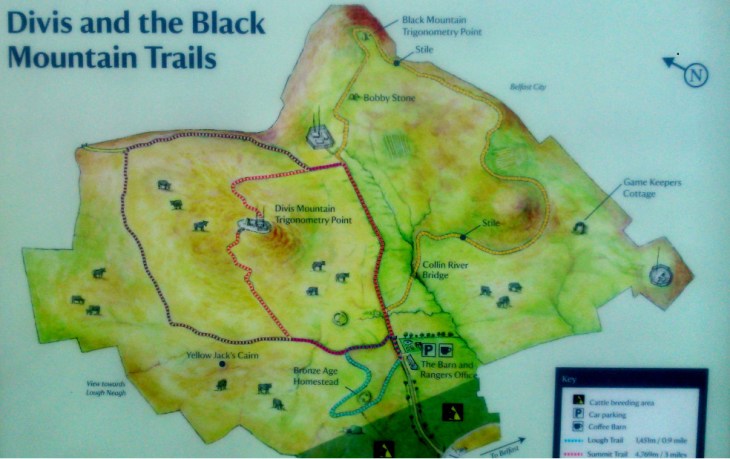
Yesterday we visited the Brú na Bóinne complex  in county Meath, an excellent and highly recommended experience.

The Brú na Bóinne complex consists of three main structures, Newgrange, Knowth and Dowth together with a plethora of satellite tombs.  It is an enigma wrapped in a conundrum.  How was it built?  This is a magnificent feat of construction and engineering, built before the invention of the wheel and metal tools. Why was it built?  Speculation abounds ( aliens not excluded).

Newgrange2

The three main structures have been accurately dated to between c. 3200 and 3100 BC. This makes them five hundred years older than the current form of Stonehenge and the Great Pyramid of Giza in Egypt , as well as predating the Mycenaean culture of ancient Greece. They have each been, very accurately, aligned with the rising or setting sun at different solstices.

Newgrange3

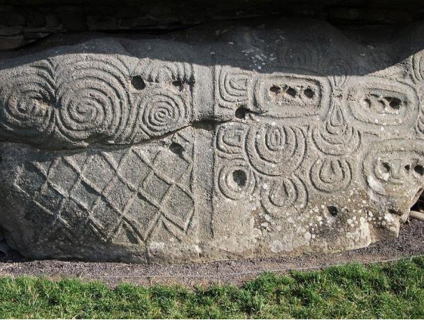
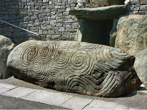
We started at Knowth and admired the many examples of, what is said to be abstract Neolithic rock art.  However, whether or not there is meaning in these swirls, chevrons and lozenges, has been lost in the mists of time and, I think, is even beyond speculation.

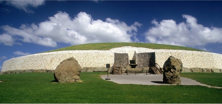
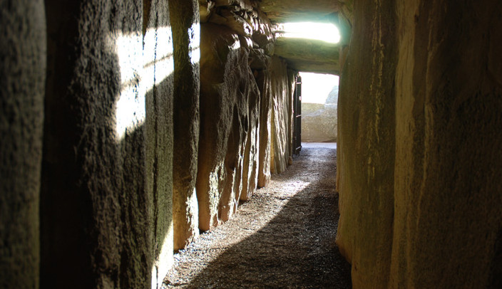
I found Newgrange more accessible. You enter through a narrow nineteen metres long passageway which ascends about a metre to reach the central chamber. However, once you reach that small corbelled space, you realise that you have not only walked nineteen metres but also travelled back in time, five thousand years.  What you are seeing and feeling is exactly what our Neolithic ancestors experienced.

Most monuments record past glories, but the people who built Newgrange were not only sun worshipers they also wanted to communicate with future generations, they were time surfers. The structure is aligned with the rising sun at the solstice, at midwinter, at the time of the shortest day, around the 22nd December .  At this date and for a few days on either side the rising sun floods along the passageway and lights up the central chamber for a brief seventeen minutes.

Newgrange 3

For those not lucky enough to be there, the effect can now be created artificially. The chamber is plunged into darkness and the artificial sun god starts his journey along the passageway.  It has a gentle hypnotic effect and you become very much aware that you are not only standing in the place of those Neolithic people on that very first midwinter morning  five thousand years ago but also in that of future generations, five thousand years and millennia to come.

The concept of long periods of time is a difficult one for our human brain to conceive, we tend to think in terms of our own life span.  However, the light will continue to flood in every midwinter morning as long as there is a sun to shine and, maybe, long after there is anyone left to enjoy it.

Colin Glen Forest Park


Colin Glen 1

This is not only a gem of a walk right in the city of Belfast  but also gives easy access to the mountains and much longer treks, for example, Black Mountain to Cavehill.  However, it is a muddy one and there are a couple of streams to cross.  If you like getting really close to mother nature, then this is the one for you.  For a map, statistics and waymark photographs, click on the link to Wikiloc:

http://www.wikiloc.com/wikiloc/view.do?id=13407236

Colin Glen 2

We started at the Colin Glen Centre at 163 Stewartstown Road and followed the main path always keeping to the right, along the river, until we reached the bridge at the Glen Road.  We passed under the bridge and climbed up the steps on the right and then turned left to follow a smaller track beside the boundary wall.   Shortly after this path drops down to cross a river, there is a marker post taking you right and to a flooded quarry.

At this point, we had a choice to go right to reach Divis and Black Mountain or left to the continue Colin Glen Circuit to the Rumble Hole, an impressive waterfall.

Colin Glen 4

On this occasion, we went left and having enjoyed the delights of the Rumble Hole, we retraced our steps but kept straight rather than turning left to the quarry.  After some scrambling, we found the track on the other side of the glen.  This track brought us to a river crossing, then a climb up the slope on the far side to find the Mass Rock.

Colin Glen 8

From the Mass Rock, we followed a track past some old industrial buildings and back to the Glen Road.  We turned left, entered Colin Glen Forest Park again and retraced our steps to the car park.

Colin Glen 7


Dungonnell and Glenariff Circuit

Glenariff

This is a beautiful 21 kilometres walk on minor roads and forest tracks.  For a map and statistics click on the link to Wikiloc:

id=13315442http://www.wikiloc.com/wikiloc/view.do?id=13315442

This walk starts in the village of Cargan which is on the A43 to Cushendall/Waterfoot. Park on Gortnageeragh Road, the first on the right as you enter the village.  Follow the road straight ahead, away from the village, to reach Dungonnell Road, where you turn left.  Follow Dungonnell Road past the dam and to the edge of Glenariff Forest Park.

Glenariff3

Enter the forest, at the first intersection turn right and continue along this track until you emerge into great views of Glenariff Glen

Glenariff2

(from Irish: Gleann Aireamh, meaning “valley of the ploughman/arable valley”) and  clearly marked signs for the Visitors’ Centre and the Waterfall Trail.

Glenariff1

Having enjoyed the waterfalls, return to the visitors centre and follow the signs for exit and the A43.  Cross the A43 and enter the forest again to follow a clear track, keeping left and crossing a small river, to emerge onto the  B14.  Turn right on the B14 (this is a busy road) and after a short distance, turn left uphill into the forest ( Aganlane).

Glenariff9

Turn left on the forest path and this will lead you to a minor road which will bring you full circuit back to Cargan


Tuatha Dé Danann

Tuatha Dé Danann

This is a painting called “Tuatha Dé Danann”.  It is oil on canvas, 1X1.5 metres and is the first of my Spanish/Irish connections.

The Tuatha Dé Danann (usually translated as “people of the goddess Danu”) are a supernatural race in Irish mythology.  They are thought to represent the main deities of pre-Christian Gaelic Ireland.  In ancient writings, they are depicted as kings, queens, and heroes of the distance past as well as fallen angels who were neither good nor evil.  They were a cool people and favoured dark clouds as a means of transport.  They were in possession of the island of Ireland when happened the Milesian invasion.  The Milesians came from the north-west of the Iberian Peninsula (present day Galicia and Northern Portugal).  After some tricky negotiations, the Milesians agreed to occupy the world above ground and the Tuatha, the world below, the underworld, where they live to this very day.

My painting shows the Tuatha travelling through the underworld.  The cat-like creature is taken from an illustration in the Book of Kells.  I am sure that if the Tuatha kept a pet, it would look like this.  The red letters spell out the word Tuatha in old Irish script and below is the island of Ireland.  The three sails hint that the Milesian invasion has begun.