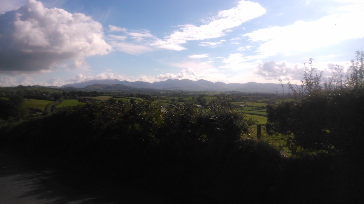
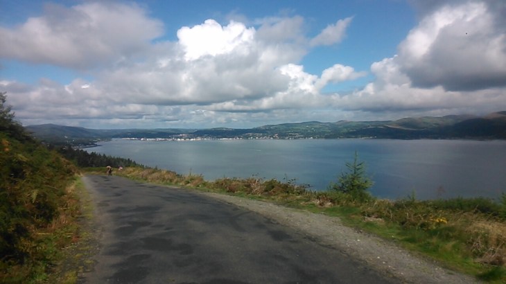
This is an easy, to moderate, 15.8 kilometers, circular walk on quiet tarmac roads and lovely old grassy tracks. It will not only take you on a ramble through both ancient and contemporary Irish history but a…
Source: Legananny Dolmen Circuit
This is an easy, to moderate, 15.8 kilometers, circular walk on quiet tarmac roads and lovely old grassy tracks. It will not only take you on a ramble through both ancient and contemporary Irish history but a…
Source: Legananny Dolmen Circuit
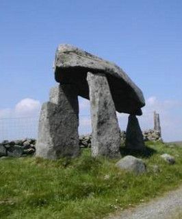
This is an easy, to moderate, 15.8 kilometers, circular walk on quiet tarmac roads and lovely old grassy tracks. It will not only take you on a ramble through both ancient and contemporary Irish history but also give you excellent views of the Mountains of Mourne. For more information, a map and statistics go to http://www.wikiloc.com/wikiloc/view.do?id=15111961
To reach the dolmen, drive straight through the village of Dromara and then the next village Finnis. Shortly after Finnis, you will pick up signs for Legananny Dolmen and Souterrain. There is a small car park beside the Dolmen. It is a very elegant structure and well furnished with information signs. The exact purpose behind its construction has been lost the mists of time. However, it is thought that the people who built it realized that countless generations had passed before them without leaving a trace of their existence. They, not only wanted to make their mark in time but also to time travel into the future and say to future generations, we were here and we were clever and sophisticated people.
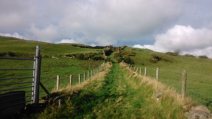
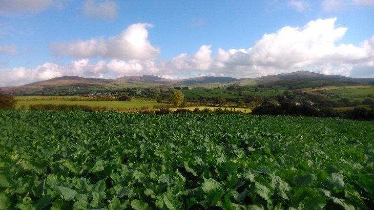
From the Dolmen, walk back the way you drove in and at the top of the hill, you will see a wooden sign marked Footpath. Take this, keeping right at the fork, and it will lead you to the Slievenaboley Road. Turn left to the car park and viewpoint. Here you will get excellent views of the Mountains of Mourne, Slieve Croob, the Belfast Hills and,on a clear day, the Sperrins.
Follow the road downhill and then turn right along Lighthouse Road. At the top of the hill, take a right along a path marked Moat Pad Footpath. Follow the yellow arrows , keeping left. “Moat” refers to several ringforts or raths, to be found at the end of the track. Look out for a gate on the right and take the track at first going up a hill and then down through a farm-yard. The farmer is very friendly and always happy to stop for a chat. Red kites are frequently seen in this area. Were the farm track reaches the tarmac road, look in the fields directly in front and to the left and you will see two large raths or ringforts, encircled with trees.
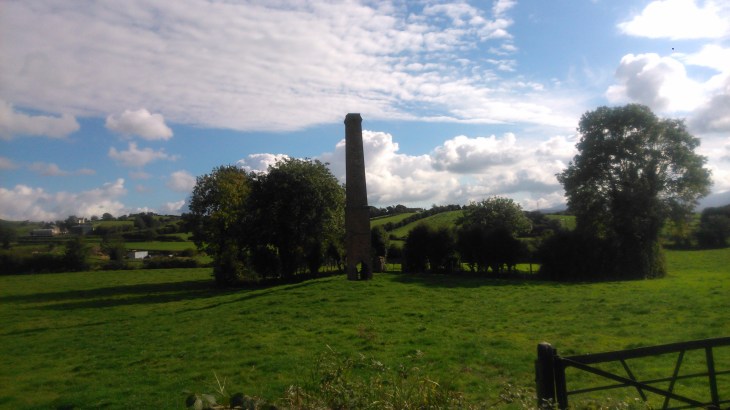
Go left on the tarmac road and this will quickly bring you into the village of Dechomet. There is some debate as to the origin of the name Dechomet but it is thought to come from the Irish Deas Coimhéad – good look-out post/good prospect. Walk straight through the village and you will come to something remarkable. In a field on the left, you will see a substantial red brick chimney, with a rath behind enclosing an ancient circular graveyard. The story goes that the chimney was the beginning of a linen factory. The gravestones were removed prior to preparing the ground for the factory. The linen industry collapsed almost overnight under the pressure from cheap imports and work stopped on the factory. No record had been kept of the original positions of the gravestones, so rather than replace them with the wrong owner, they were placed in a circle at the edge of the rath.
From here, return to the village where Turley’s Bar is worth a visit. Now, take the Ballymacilreiny Road. This road undulates through low farmland passing Derryneil Baptist Church. When you reach the T-junction with the Millvale Road, go left and within 100 meters, turn left again on Adder’s Loanin Footpath. Follow this beautiful old grassy track past some ruined cottages, through another farmyard and you will eventually come back full circle to Lighthouse Road. Retrace your steps going left along Lighthouse Road. At the T-junction go left and then sharply right, climbing up Legananny Hall Road. When you come to the Orange Hall go sharp left and this will bring you back to the dolmen and the car park.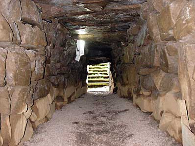
The souterrain is also worth a visit. It is well signposted with plenty of information. It dates from the 5th century and when you are in the passageway or one of the chambers, place your hand on any of the stones and there is a very good chance that the last person to touch that particular stone lived in the 5th century.
This is a painting from my forthcoming exhibition, it is called “Dreaming of Tartessos”, it is oil on canvas and 50×70 centimeters. It, together with all the other images, was insp…
Source: Dreaming of Tartessos
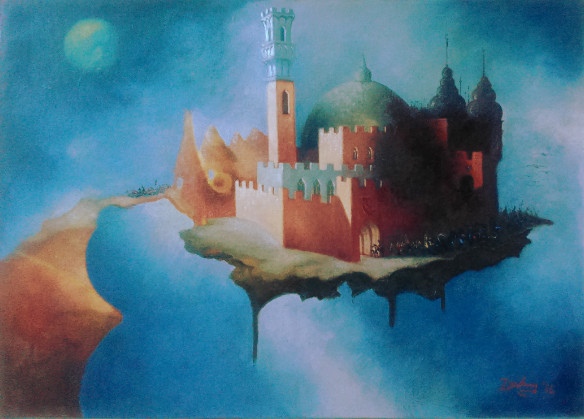
This is a painting from my forthcoming exhibition, it is called “Dreaming of Tartessos”, it is oil on canvas and 50×70 centimeters. It, together with all the other images, was inspired by a 1000 kilometers pilgrimage walk I made in Spain this year, from Seville in the south to Santiago de Compostela in the north. The original idea behind the project was to make Celtic/Spanish connections and, of course, the ancient Celtic city or kingdom of Tartessos was never far from my mind.
Tartessos was once thought to be a myth but in the light of more recent evidence is slowly emerging into reality. It was a fabulously rich region in the extreme southwest of the Iberian peninsula. Of most interest to me is the theory that Tartessos and the language spoken, Tartessian, was partly or wholly Celtic. In fact, John Koch in his article in History Ireland suggests that Tartessian is ‘more than a little bit Celtic’ and adds a new twist to the assertion, long since dismissed as invention, that the Gaels (Milesians) originated in the Iberian Peninsula. For more information on this and much more go to http://www.historyireland.com/pre-history-archaeology/tartessian-europes-newest-and-oldest-celtic-language/
But, how best to depict Tartessos? I see it as an ancient city with hoards of travelers and traders constantly passing through its gates but also, with all it represents, a thought or an idea hanging in the mists of time.
The exhibition will open on Thursday 1 December, in the Cultúrlann, Falls Road, Belfast.
This is one of four drawings which will be shown at my forthcoming exhibition in December 2016. The exhibition will be based on my experiences on walking the 1000 kilometres long Via de Plata from…
Source: Where Eagles Fly
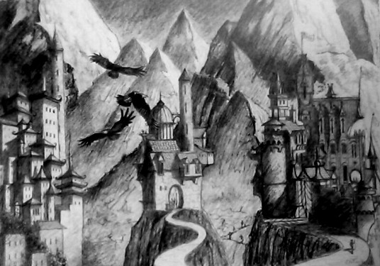
This is one of four drawings which will be shown at my forthcoming exhibition in December 2016. The exhibition will be based on my experiences on walking the 1000 kilometres long Via de Plata from Seville in southern Spain to Santiago de Compostela in the north. My previous blogs are available at the bottom of the home page on my website http://www.dandowling-artist.com
One of my initial ideas on undertaking this journey was to investigate ancient Celtic/Spanish connections. I was especially interested in the fabulously rich, pre-Roman, Celtic city of Tartessos. Tartessos was once thought to be a myth but the myth is slowly merging into reality. For more information go to John Koch’s article http://www.historyireland.com/pre-history-archaeology/tartessian-europes-newest-and-oldest-celtic-language/ in which he suggests that Tartessian is ‘more than a little bit Celtic’ and adds a new twist to the assertion, long since dismissed as invention, that the Gaels (Milesians) originated in the Iberian Peninsula.
In Extremadura, Tartessos is accepted as a historical fact and, frequently mentioned, are three villages located in a very remote valley, in the northwestern part of the province, where, it is said, the remnants of the Tartessian language is still spoken. The language is called Fala. The three villages are nor only remote from both Spain and Portugal but so remote from each other that three distinct dialects have emerged although they are mutually intelligible with each other.
San Martín de Trevejo is the smallest of the three, with a population of 926 people and their dialect of Fala is called “Manhegu”. Eljas has a population of 1046 who speak “Lagarteiru” and in Valverde del Fresno with a population of 2576 they speak “Valverdeiru”. I managed to visit San Martín de Trevejo and listened to the Fala language. Was I listening to a version of ancient Tartessian and according to John Koch, Irish? It was interesting, to say the least. However, even more, intriguing is the fact that the Fala language whilst unrelated to modern-day Spanish or Portuguese has always been mutually intelligible with Galician. Just think of the Milesian ( modern-day Galicia) invasion of Ireland, as recorded in “Leabhar Gabhála na hÉireann”. It is difficult not to draw conclusions.
https://en.wikipedia.org/wiki/Lebor_Gab%C3%A1la_%C3%89renn
The drawing shows the three villages, very much on a “once upon a time” theme, high in the mountains where the eagles fly. The exhibition will open on Thursday 1 December 2016, in the Cultúrlann, Falls Road, Belfast.
This is the first of a series of blogs which will give some background to the paintings and drawings, in my forthcoming exhibition. They were inspired by a 1000 kilometres walk in Spain, called the…
Source: Walking to the Edge of Reality
This is the first of a series of blogs which will give some background to the paintings and drawings, in my forthcoming exhibition. They were inspired by a 1000 kilometres walk in Spain, called the Via de Plata. I recorded my experiences first hand with drawings and sketches en route and wrote a daily blog which can be read at the bottom of the home page on my website www.dandowling-artist.com. However, the final images would not exist without the physical process of walking 1000 kilometres, without the people I met, and without the amazing experiences, together they make one piece of work.
The Via de Plata is one of the many Camino de Santiago pilgrimage routes. It is by far the longest and runs from Seville, in the south, to Santiago de Compostela, in the north, almost the total length of the Iberian peninsula. The original Caminos were walked by the Celts in those halsian pre-Roman days. These ancients followed lines of energy, ley lines, using the old magic and the old knowledge. Their final destination was not the present day Santiago de Compostela, but the mystical Finisterre. Finisterre, as the name implies, was thought to be the end of the world. Our ancestors stood on the very edge of the known world and watched their sun-god disappear into the west every evening, only to reappear in the east every morning. By any standard, this must have been an amazing experience. Did they accept this as their reality or were they deliberately exploring ways to obtain insight into their world by parting the veil between the physical and the spiritual.
 Is this the reason why people have always, and nowadays increasingly more so, walked Caminos? Do they want to step out of the routine of their life and walk to the limit of their reality and peer over the edge? I think this is feasible and perfectly possible to do so, provided you are prepared to leave the paraphernalia of everyday life behind.
This was certainly my experience on walking across the Meseta with my friend Victor. The Meseta is a high central plateau, ranging from 400 to 1000 metres in height, and occupies 40% of Spain’s land mass. We spent an amazing few weeks walking across a vast landscape, under massive skies, enjoying endless discussions and putting life and reality to rights. For me, because there was nothing even remotely familiar and nothing to cling on to, my reality, quickly, became living in the moment. I was definitely somewhere else. Of course, this can only be appreciated in hindsight. Victor was living in a reality nearby, possible closer to the edge.
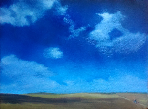
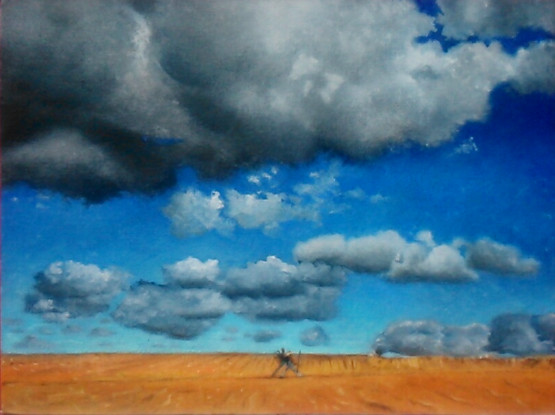
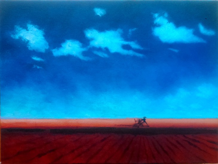
The three paintings illustrated are from a series of five. They will be the smallest pieces in the exhibition, but depict vast spaces, with tiny figures walking through their lives.
The exhibition will open on Thursday 1 December 2016, in the Cultúrlann McAdam Ó Fiaich, 216 Falls Road, Belfast BT12 6AH.
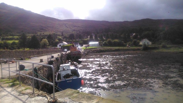
This is a beautiful 15.6 kilometres walk along a gorgeous coastal path and then forest tracks. It is easy to moderate and accessible to everyone, for a map and statistics go to . We parked in Omea…
Source: Omeath-Carlingford Circuit
This is a beautiful 15.6 kilometres walk along a gorgeous coastal path and then forest tracks. It is easy to moderate and accessible to everyone, for a map and statistics go to
http://www.wikiloc.com/wikiloc/view.do?id=14880444 .
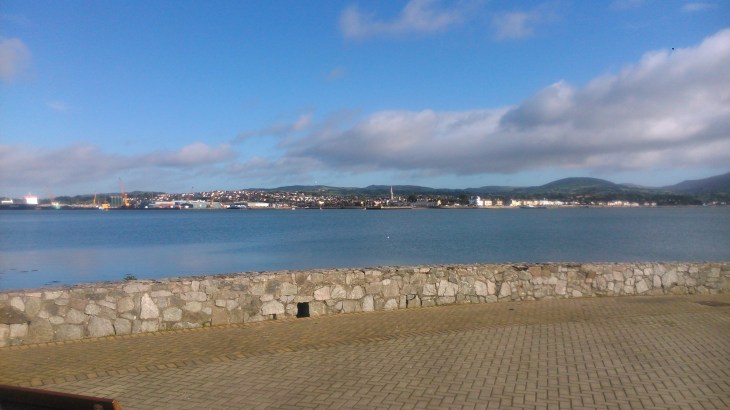
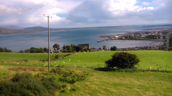
We parked in Omeath at the shore front and walked along the coastal path towards Carlingford. This path joins up with the Greenway or An Bealach Glas which follows the line of the old Newry to Greenore railway track.
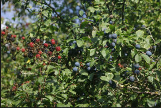
If you are thinking of doing the walk at this time of the year, September/October, bring a few containers, sloes and blackberries are abundant.
The Greenway is 7 kilometres long and, apart from a short section on the road, with a footpath, it follows the coastline into Carlingford.
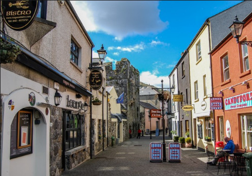
Carlingford is well worth a wander around and a cup of coffee or something more substantial. Once ready, you can simply return along the Greenway, or if you feel like a moderate challenge, walk up the fairly steep hill straight ahead from the village square. The hill levels out at the intersection of several minor roads and tracks. Turn right and follow the yellow walking man signs on black posts. They will lead you along a beautiful forest walk with wonderful views of Carlingford and Carlingford Lough.
Keep following the signs for roughly 7 kilometres. There are chances to drop down sooner, but the sooner you drop down the further you will have to walk along the busy and narrow main road. The forest path will eventually turn into a narrow track, but still, well sign posted,and ends at a stile. Turn right at the stile down a rough grassy track which will bring you onto a tarmac road and then the main road again. However, if you turn left, on the main road, you are only 200 metres from the turn back down to Greer’s Quay and the Greenway.
The section on the main road should be negotiated with care, it is both narrow and busy with very little room for walkers. Once you reach Greer’s Quay, it is a very pleasant 3 kilometres back to Omeath along the Greenway.
